Photographs of Grassy Island
Fort William Augustus 1725 – 1744
National Historic Site
Grassy Island
Canso Harbour Guysborough County Nova Scotia
Once a thriving community of fishermen and merchants
from New England, Grassy Island became a casualty of the
rivalry between England and France for control of North America.
After the French attacked and burned it in 1744, the island lay
abandoned and forgotten for more than 200 years. Much of
what is now known of this settlement is the result of
recent historical and archaeological research.
1744 March 11: War against England is declared by France.
1744 April 9: War against France is declared by England. This conflict is now known as the War of the Austrian Succession, or in the simpler American nomenclature, “King George’s War,” or “Governor Shirley’s War.”
These dates are from:
The Struggle for Acadia: The Final Phase 1744-1779
by W.E.Daugherty, Indian and Northern Affairs Canada
1744 May 3 (N.S.): Louisbourg gets the news (a ship from St. Malo) that France has declared war against England.
1744 May 13 (O.S.) or 24 (N.S.): The French attack and take Grassy Island Fort at Canso.
— Reference:
Significant Historical Happenings By Year: 1742-44 by Peter Landry
http://www.blupete.com/Hist/Dates/1742-44.htm
Timeline of the Seven Years War 1754-1763
https://ns1763.ca/remem/7yw-timeline-w.html
The destruction of Grassy Island by France in May 1744 was an early event in the preliminary skirmishes between England and France, that led to the SevenYearsWar.
GPS location of the fort site on Grassy Island:
45°20’16″N 60°58’20″W
Google map showing the location of the British fort at Canso, 1744
GPS location of the Parks Canada interpretative centre
and ferry terminal at #1465 Union Street, Canso
45°19’57″N 60°58’55″W
Google map showing the location of the Parks Canada interpretative centre in Canso

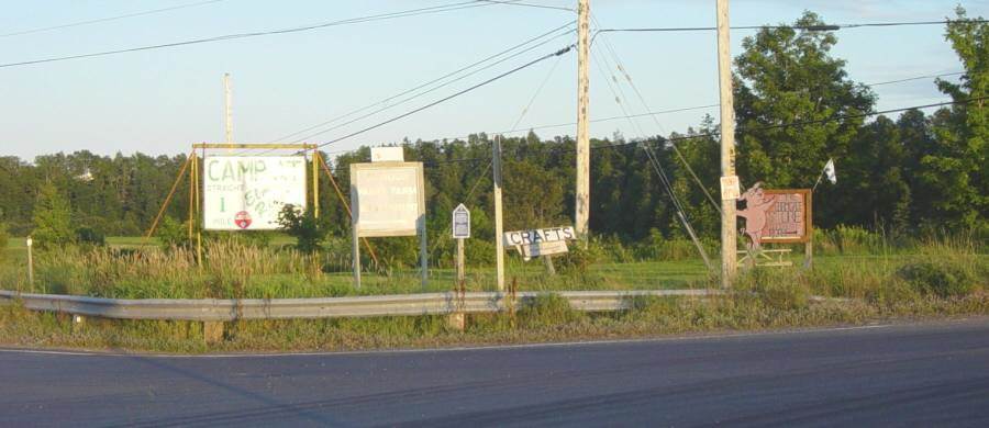
Grassy Island National Historic Site sign at 1465 Union Street, Canso.
Photographed on 10 May 2007

Map showing location of British fort on Grassy Island, 1744

Grassy Island as seen from the east end of Union Street, Canso
Photographed on 18 August 2005

Looking eastward toward Grassy Island.
Photographed on 18 August 2005

Approaching the landing stage on the north side of Grassy Island.
Photographed on 18 August 2005

Landing on Grassy Island. The ruins of Fort William Augustus
lie at the top of the hill beyond the interpretative hut.
Photographed on 18 August 2005

Looking southwest across the ruins of Fort William Augustus toward the town of Canso.
Photographed on 18 August 2005

Looking northeast across the ruins of Fort William Augustus.
Photographed on 18 August 2005
The Interpretative Panel at Grassy Island Fort
a.k.a. Fort William Augustus
The photographs below were taken on 18 August 2005.

Detail of the interpretative panel at the ruins of Fort William Augustus.

Looking northwest. Beyond the interpretative panel are the ruins of Fort William Augustus.

Detail of the interpretative panel at the ruins of Fort William Augustus.

Detail of the interpretative panel at the ruins of Fort William Augustus.

Detail of the interpretative panel at the ruins of Fort William Augustus.

Detail of the interpretative panel at the ruins of Fort William Augustus.

Detail of the interpretative panel at the ruins of Fort William Augustus.

Detail of the interpretative panel at the ruins of Fort William Augustus.

Detail of the interpretative panel at the ruins of Fort William Augustus.

Detail of the interpretative panel at the ruins of Fort William Augustus.
The Interpretative Hut at Grassy Island landing

The interpretative hut at Grassy Island landing.

Detail of west interpretative panel at Grassy Island landing hut.

West interpretative panel at Grassy Island landing hut.

Detail of west interpretative panel at Grassy Island landing hut.

Detail of west interpretative panel at Grassy Island landing hut.

Detail of west interpretative panel at Grassy Island landing hut.

Detail of east interpretative panel at Grassy Island landing hut.

East interpretative panel at Grassy Island landing hut.

Detail of east interpretative panel at Grassy Island landing hut.

Detail of east interpretative panel at Grassy Island landing hut.

Detail of east interpretative panel at Grassy Island landing hut.
The Interpretative Centre
at 1465 Union Street, Canso

The interpretative centre on Union Street, Canso.

Map of Canso Harbour, showing Grassy Island.

The interpretative centre on Union Street, Canso.

The interpretative centre on Union Street, Canso.

The interpretative centre on Union Street, Canso.

The interpretative centre on Union Street, Canso.

Map done by order of His Excellency Montagu Wilmot, Esq.
Governor and Commander in Chief of Nova Scotia
by Charles Morris, chief surveyor 1764
Source:—
Library of Congress Geography and Map Division, Washington, D.C.

1764 Map of Canso harbour.
“Fort Island” is now known as Grassy Island.
“Wilmot Town” is now known as the Town of Canso.
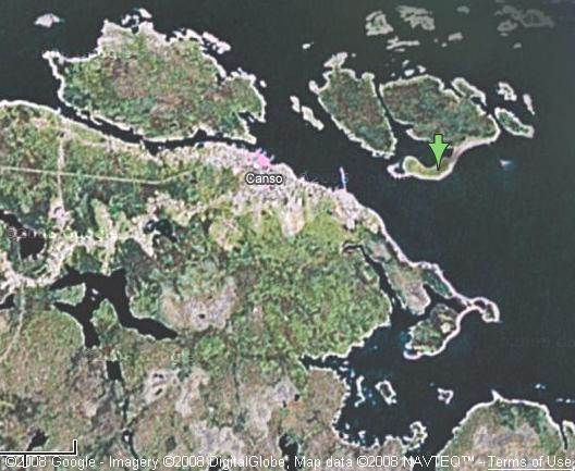
Compare the very accurate 1764 map (above) with a recent aerial photograph (below).
2007 satellite photograph of Canso harbour.
Grassy Island is marked by the green arrow.

Detail: 1764 Map of Canso harbour.
“Fort Island” is now known as Grassy Island.
“Wilmot Town” is now known as the Town of Canso.
Water depths are in fathoms.
One fathom = six feet = 1.83 metres
Grassy Island Virtual Tour
Includes an aerial photograph of the Fort William Augustus site
http://epe.lac-bac.gc.ca/100/205/301/ic/cdc/archaeology/
second/impact/nhs/virtual/virtualtour.html
Canso Islands National Historic Site of Canada by Parks Canada
http://www.pc.gc.ca/lhn-nhs/ns/canso/natcul/index_e.asp
The British Administration in Nova Scotia: 1714-1739
by the Department of Indian and Northern Affairs
…Philipps was also undoubtedly discouraged by the violence which
broke out at Canso. The Micmacs, increasingly incensed by the incursions
of Massachusetts fishermen into Nova Scotia waters, attacked and killed
a number of them while capturing their fishing boats. Philipps retaliated
by building a small fort at Canso and by garrisoning it with three
companies of troops from Annapolis…
http://www.aadnc-aandc.gc.ca/eng/1100100028966#chp2
Timeline: Grassy Island and Canso, 1600-1699
http://epe.lac-bac.gc.ca/100/205/301/ic/cdc/archaeology/
second/history/1600timeline.html
Timeline: Grassy Island and Canso, 1713-1744
http://epe.lac-bac.gc.ca/100/205/301/ic/cdc/archaeology/
second/history/171344.html
Timeline: Grassy Island and Canso, 1745-1963
http://epe.lac-bac.gc.ca/100/205/301/ic/cdc/archaeology/
second/history/174500.html
Brief Biographies
Richard Philipps by Peter Landry
http://www.blupete.com/Hist/BiosNS/1700-63/Philipps.htm
Richard Philipps Dictionary of Canadian Biography
https://ns1763.ca/bio/7bio-91587-philipps1661.html
Richard Philipps Wikipedia
http://en.wikipedia.org/wiki/Richard_Philipps
Alexander Cosby by Peter Landry
http://www.blupete.com/Hist/BiosNS/1700-63/Cosby.htm
Alexander Cosby Dictionary of Canadian Biography
http://www.biographi.ca/EN/ShowBio.asp?BioId=35400
Lawrence Armstrong by Peter Landry
http://www.blupete.com/Hist/BiosNS/1700-63/Armstrong.htm
Lawrence Armstrong Dictionary of Canadian Biography
https://ns1763.ca/bio/7bio-34734-armstrong1664.htmll
Lawrence Armstrong Wikipedia
http://en.wikipedia.org/wiki/Lawrence_Armstrong
Edward How by Peter Landry
http://www.blupete.com/Hist/BiosNS/1700-63/How.htm
Edward How Dictionary of Canadian Biography
https://ns1763.ca/bio/7bio-35532-how1702.html
Jean Paul Mascarene by Peter Landry
http://www.blupete.com/Hist/BiosNS/1700-63/Mascarene.htm
Paul Mascarene Dictionary of Canadian Biography
https://ns1763.ca/bio/7bio-35647-mascarene.html
Paul Mascarene Wikipedia
http://en.wikipedia.org/wiki/Paul_Mascarene
Nicholas Denys by Peter Landry
http://www.blupete.com/Hist/BiosNS/1600-00/Denys.htm
Nicolas Denys Dictionary of Canadian Biography
http://www.biographi.ca/EN/ShowBio.asp?BioId=34290
Nicolas Denys Wikipedia
http://en.wikipedia.org/wiki/Nicolas_Denys
Patrick Heron Dictionary of Canadian Biography
https://ns1763.ca/bio/7bio-91401-heron1709.html
Agathe de Saint-Etienne de la Tour (1690-c.1743)
a.k.a. Agathe Bradstreet, Agathe Campbell
http://www.biographi.ca/EN/ShowBio.asp?BioId=35211
Grassy Island National Historic Site
Cape Breton in Transition: Economic Diversification and Prospects for Tourism
…By the early 1990s Grassy Island National Historic Site was in operation.
The mainland visitor centre provided visitors with an opportunity to familiarize
themselves with the site’s story before taking a boat to the Island.
Once on the Island, visitors could view the traces of the fort on top of the
hill and inspect the sites of other structures which once stood on the Island.
None of the original structures have been reconstructed, but Parks Canada
has carried out additional archaeological investigations in 1993 and 1994,
providing summer employment and additional government spending in the
Canso area. Much still remains to be done, however, before tourism begins
to make a substantial contribution to the economy of the Canso area.
Grassy Island attracts only 3,000 to 4,000 visitors annually…
http://fortress.uccb.ns.ca/search/Proc95_10.htm